

This consultation for the Draft Neighbourhood Development Framework for Holt Town has now ended. Thank you to everyone who took part and provided feedback.
Welcome to the public consultation on the Draft Neighbourhood Development Framework for Holt Town.
This interactive website will guide you through Manchester City Council's vision to transform this
part of East Manchester into a new mixed-use neighbourhood.
Holt Town is the area between the City Centre and Sport City and the Etihad Stadium. The Ashton Canal and the River
Medlock run through the site. Today there remains a woodland presence at Holt Town and our vision
is to build on this foundation. We want to regrow Holt Town like a woodland. A new town in the city.
Help us grow the Holt Town of tomorrow: We are keen to hear your views about the approach we have taken
and invite you to give us your views at the end. You can also view the draft NDF in full
at the end of this website.
The consultation will close on Sunday 29th September 2024.
Look out for green highlighted hints like this. They will indicate interactive features on the map. In each section, you can zoom, pan and scroll across the map to explore it in more detail.
What happens next? Your feedback will inform the content of the final NDF.
Manchester City Council and the design team will review the Draft NDF. Feedback received from residents,
landowners, statutory stakeholders and the business community will be considered. The final NDF will be
considered for endorsement by the Manchester City Council Executive in the beginning of 2025.
Holt Town, Past and Present: from Factory Town to Woodland Town
Holt Town, Factory Town (1700s - 1940)
In the 1700s, Holt Town was established by David Holt as Manchester's first factory colony.
It was pivotal to Manchester's industrial revolution. The products manufactured in its factories
and mills were exported all over the globe.
The map shows how Holt Town looked in 1888. Click on the map markers to view historic photographs of area.
Holt Town, Ghost Town (1940 - 1990)
Changing patterns in trade and investment caused decades of decline from the early 20th Century.
People and businesses moved away from the area.
Holt Town, Frontier Town (1990 - 2020)
In recent decades, Holt Town has remained largely untouched by regeneration. There is an opportunity for Holt Town to
be home to pioneering economic, social and cultural activity, and a mixed-use, residential-led neighbourhood.
Holt Town, Woodland Town (2020 onward)
Despite the decline, pockets of vegetation have reclaimed parts of the site. These pockets lay the
foundation for a new concept, 'Woodland Town'.
Key features of Holt Town today
- Two distinct waterways, the Ashton Canal, and the River Medlock, come together at Ashton Canal Park.
- Historic mill buildings such as Brunswick Mill, Wellington Mill, Bridge 5 Mill, and Hope Mill line the Ashton Canal. These reflect the area’s industrial heritage. Some of these buildings have taken on a new life as hubs for creative and social enterprises and small businesses.
- Ecology: Pockets of vegetation have reclaimed parts of the area. This is the foundation for a new concept 'Woodland Town', that is at the heart of the approach to this NDF.
- Uses: Holt Town features a few homes alongside remnants of its industrial past. A variety of light industrial and warehousing businesses are all present.
- Holt Town consists largely of post-industrial, contaminated and under-used brownfield land. The area is currently under-invested and is at risk of anti-social behaviour. Our new plans seek to address these problems and provide long-term solutions.
Map Key
 |
Holt Town NDF Boundary |
 |
Photographs of Holt Town |
A vision to regrow the community like a woodland
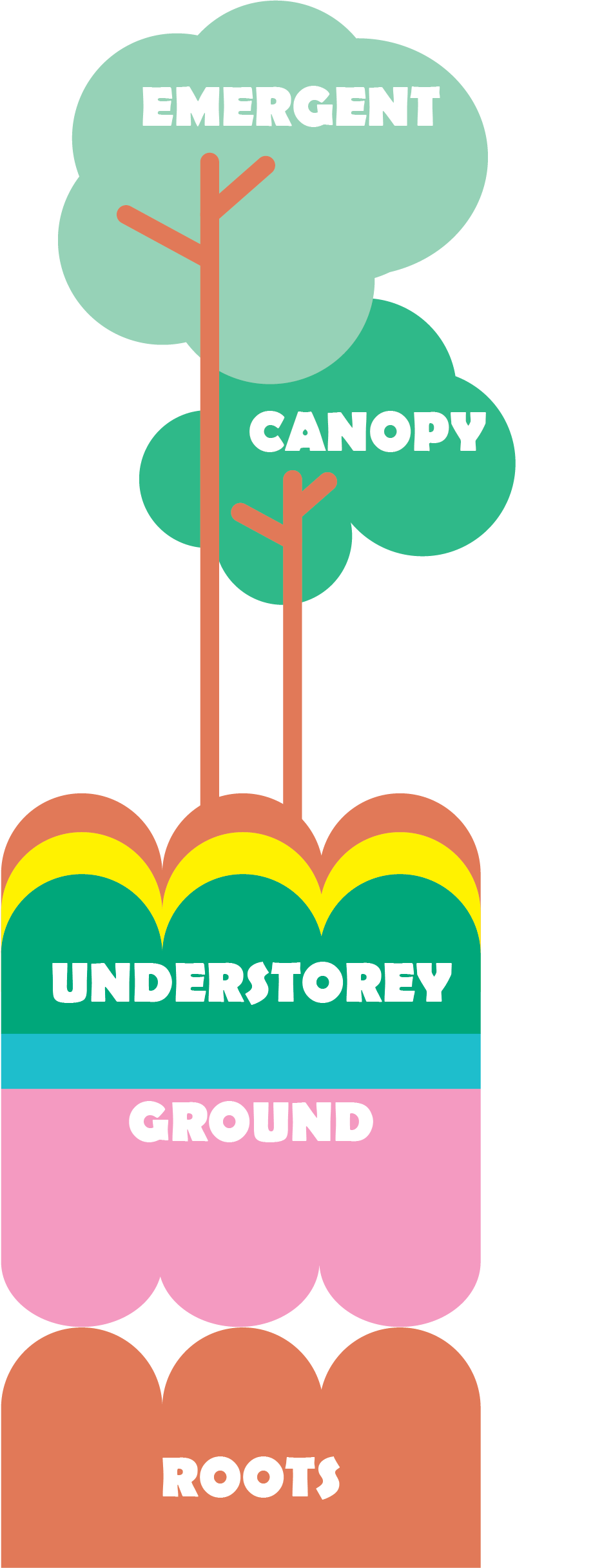
Our vision is to 'regrow the community like a woodland'. This is inspired by the idea of
working around the pockets of nature that have reclaimed parts of the site.
We have identified five layers of place to regrow a neighbourhood at Holt Town. Our
inspiration was the anatomy of a woodland, rooting and sustaining:
- Roots
- Ground
- Understorey
- Canopy
- Emergent
Click on the map markers to read more about these five layers.
Map Key
|
|
Holt Town NDF Boundary |
 | Railway tracks |
| Metrolink tracks | |
 | Metrolink stations |
 | Holt Town woodland layers |
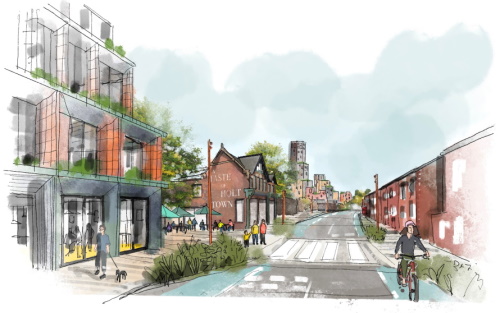
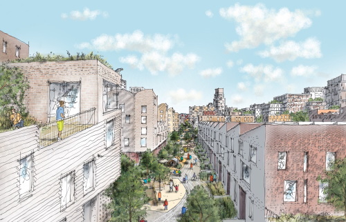
A new town in the city: Holt Town, Wood Town
Holt Town has the potential to be a pioneering mixed-use, residential-led neighbourhood.
This will breathe new life into this part of East Manchester.
The draft framework suggests the new Holt Town could be a neighbourhood with 4,500 new homes.
This aims to include 1,000 affordable homes.
The map shows how Holt Town could look with the draft framework.
Alongside the diverse ecological setting of the Medlock Valley and the historic character of the Ashton Canal corridor, Holt Town can be a rooted, layered, and connected piece of Manchester. A new town in the city.
Map Key
|
|
Holt Town NDF Boundary |
| Railway tracks |
| Metrolink tracks | |
| Metrolink stations |
Land uses, housing and social infrastructure: Holt Town, Rooted Town
Holt Town could deliver a variety of uses. These could amplify the Area's established network of creative and social enterprises. Opportunities include the clustering of commercial and creative uses along the area we are calling the Ridge, along the southern edge of the canal. This would build upon the existing businesses along this edge.
Drag the slider below to toggle between the ground floor and upper floor uses on the map.
Map Key
|
|
Holt Town NDF Boundary |
| Railway tracks |
| Metrolink tracks | |
| Metrolink stations |
 | Multi-use Mobility Hub |
| Indicative ground floor uses | |
 |
Predominantly residential |
 |
Predominantly mixed-use |
 |
Predominantly commercial |
 |
Predominantly cultural/community |
 |
Predominantly leisure/recreation/health & well-being |
| Primary frontage | |
| Indicative upper floor uses | |
|
|
Predominantly residential |
|
|
Predominantly commercial |
|
|
Predominantly cultural/community |
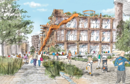
Scale, density and built form: Holt Town, Layered Town
The framework proposes to deliver 4,500 homes at Holt Town. A variety of homes is paramount
to the success of Holt Town. An inclusive and diverse neighbourhood includes low-rise
townhouses and maisonettes to taller buildings.
The approach to scale and massing at Holt Town has been informed by an in-depth analysis of
site constraints and considerations. These include thorough density and layout testing.
The following building typologies could be appropriate:
- Mid to high-rise pavilion buildings
- Townhouses
- Maisonettes
- Low to mid-rise courtyard blocks
- Mid-rise apartment blocks
- Landmark tower
Map Key
|
|
Holt Town NDF Boundary |
| Railway tracks |
| Metrolink tracks | |
| Metrolink stations |
| Indicative maximum heights | |
 |
Up to 35 storeys |
 |
Up to 25 storeys |
 |
Up to 22 storeys |
 |
Up to 18 storeys |
 |
Up to 15 storeys |
 |
Up to 12 storeys |
 |
Up to 8 storeys |
 |
Up to 5 storeys |
 | Opportunity for a landmark building |
Movement and connections: Holt Town, Connected Town
Holt Town will be more accessible and connected to surrounding areas. There is potential
for a compact and walkable street network that puts pedestrians first. This will help manage
the heavy movement between the City Centre and Sport City and the Etihad Campus.
The area's proximity to the City Centre creates a potential for a low-car neighbourhood. Minimal
on-street parking will promote sustainable travel and safer streets.
Map Key
|
|
Holt Town NDF Boundary |
| Railway tracks |
| Metrolink tracks | |
| Metrolink stations |
| Multi-use Mobility Hub |
| Existing recreational links | |
 |
City Link |
 |
Ashton Canal Towpath |
| Street hierarchy | |
 |
Pedestrian play street (1km long) |
 |
Pedestrian green link |
|
|
Primary vehicular route (with cycle infrastructure) |
 |
Secondary vehicular route (with cycle infrastructure) |
 |
Tertiary vehicular route |
Public realm and ecology: Holt Town, Woodland Town
There is an opportunity to deliver new and enhanced public spaces at Holt Town. We would like to
enhance the River Medlock and Ashton Canal corridors. The planting approach will create and restore
natural ecosystems and habitats.
These habitats include meadows, woodlands, hedgerows, and wetlands. Connecting both with a high-quality
network of landscaped streets will enable the movement of people and manage drainage.
Map Key
|
|
Holt Town NDF Boundary |
| Railway tracks |
| Metrolink tracks | |
| Metrolink stations |
| Multi-use Mobility Hub |
| Existing recreational links | |
|
|
City Link |
|
|
Ashton Canal Towpath |
| Key public realm and planting features | |
|
|
Pedestrian play street (1km long) |
 |
Enhancement of canalside planting |
 |
Riverside Meadow |
 |
Riverside Woodland |
 |
Wet Woodland Spines |
 |
Spinney / former Holt Town Reservoir |
 | Copse (enhancement of existing tree groupings) |
 | Glade |
 | New park / significant open space |
 | Canalside open space |
Play and recreation: Holt Town, Play Town
Play is key to fostering a family-friendly and intergenerational public space at Holt Town. We propose
to create a "Play Link"; a one kilometre long, car-free, pedestrian-friendly route along Lind Street.
This could connect St Anne's Primary School and Park View Community School. It could complement links
between the City Centre, Sport City and Etihad Campus, and neighbouring communities.
We imagine the transformation of Ashton Canal Park into the Confluence Park and Playground. The word
"confluence" means a meeting point. The meeting point of the Medlock River and the Ashton Canal could
be celebrated by a curated landscape. This could be the centrepiece of the neighbourhood. There is potential for an indoor
sport and play venue spilling outdoors to offer a range of activities for all ages.
Map Key
|
|
Holt Town NDF Boundary |
| Railway tracks |
| Metrolink tracks | |
| Metrolink stations |
| Multi-use Mobility Hub |
| Existing recreational links | |
|
|
City Link |
|
|
Ashton Canal Towpath |
| Key public realm and planting features | |
 |
Pedestrian play street (1km long) |
|
|
Enhancement of canalside planting |
|
|
Riverside Meadow |
|
|
Riverside Woodland |
|
|
Wet Woodland Spines |
|
|
Spinney / former Holt Town Reservoir |
| Copse (enhancement of existing tree groupings) |
| Glade |
 | Confluence Park |
| New park / significant open space |
| Canalside open space |
Water management: Holt Town, Sponge Town
Water can contribute meaningfully to positive ecological, health and wellbeing outcomes at Holt Town. The NDF promotes a 'Sponge Town' approach to promote innovative water management. This would mitigate flood risk, enhance the natural setting, and help urban areas adapt to climate change.
Map Key
|
|
Holt Town NDF Boundary |
| Railway tracks |
| Metrolink tracks | |
| Metrolink stations |
| Water management | |
 |
Infiltration pit/trench (Sustainable Urban Drainage System/SuDS) |
|
|
Swales (SuDS) |
 |
Attenuation pond |
 |
Blue roofs (SuDS to manage rain water) |
Stewardship and management: Holt Town, Steward Town
Good management and maintenance are key to the success of Holt Town. We are exploring creative and collaborative approaches to maintenance, which could ensure that the place retains its quality in the long-term.
Click on the map markers to view potential stewards for Holt Town.
Map Key
|
|
Holt Town NDF Boundary |
| Railway tracks |
| Metrolink tracks | |
| Metrolink stations |
 | Potential Stewards |
Smart infrastructure: Holt Town, Digital Town
There is an opportunity for Holt Town to be a digitally enabled neighbourhood. Residents and businesses
could have access to technology to improve their quality of life and experiences.
Digital technology could help to monitor transport, energy, water collection, lighting, etc. It could
help people engage with one another and with their environment in more interactive ways.
Click on the map markers to find out how digital technology could enable an engaged neighbourhood.
Map Key
|
|
Holt Town NDF Boundary |
| Railway tracks |
| Metrolink tracks | |
| Metrolink stations |
 | Potential Digital Technology |
Character areas: Holt Town, Diverse Town
Holt Town can be a new town in the city. Composed of five distinct sub-areas, each with their own
character inspired by the site's levels, ecology, and built character.
The following sections explore these areas in more detail.
- The Plateau
- The Ridge
- The Terraces
- The Embankment
- The Valley
Click on the map markers to view these areas.
Map Key
| Railway tracks |
| Metrolink tracks | |
| Metrolink stations |
| NDF character areas | |
 |
The Plateau |
 |
The Ridge |
 |
The Terraces |
 |
The Embankment |
 |
The Valley |
The Plateau
The Plateau forms the northern edge of the Area. It defines the transitional character of the strip of land nestled between Bradford Road and the Ashton Canal.
Click on the map markers to view key features and to see the artist's sketches for this area.
It has the potential for a sequence of lower rise buildings. These would align with those in Miles Platting and nurture a harmonious townscape along Bradford Road.
Map Key
 |
The Plateau area boundary |
| Railway tracks |
| Metrolink tracks | |
| Metrolink stations |
 | Proposed layout including buildings to be retained |
| More information |
| Artist's sketches |
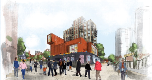
The Ridge
The Ridge is an important bridge between Ancoats and New Islington and Sport City and the Etihad Campus. It is characterised by the southern towpath and buildings lining the Ashton Canal. It invites a mix of uses within mid-rise buildings that complete the historic fabric and grain of the area. This could support the reuse of historic mill buildings, whilst also introducing new design that celebrates the heritage.
Click on the map markers to view key features and to see the artist's sketches for this area.
Enhancements to the canal towpath and access to the waterfront create opportunities for all. The benefits from this improvement to the canal could allow for increased building density.
Map Key
|
|
The Ridge area boundary |
| Railway tracks |
| Metrolink tracks | |
| Metrolink stations |
| Proposed layout including buildings to be retained |
| More information |
| Artist's sketches |
The Terraces
The Terraces emerge from the transition between the Lower Medlock and the Ashton Canal. This area is an opportunity to deliver a compact, tight-knit fabric of low-rise townhouses. These would blend living and working and address the need for family housing in proximity to the City Centre.
Click on the map markers to view key features and to see the artist's sketches for this area.
The low-rise buildings in the Terraces encourages innovative construction methods and material.
These could include timber-led construction, to support a low carbon neighbourhood.
Running through the Terraces is the Play Link, a one-kilometre car-free route. It would safely
connect St Anne's Primary School and Parkview Community School. A clear and inviting connection
to Miles Platting would be created.
Map Key
|
|
The Terraces area boundary |
| Railway tracks |
| Metrolink tracks | |
| Metrolink stations |
| Proposed layout including buildings to be retained |
| More information |
| Artist's sketches |
The Embankment
The Embankment occupies the site of the former Holt Town Reservoir. It would define the transition between the Valley and the Terraces. A memorable and inviting arrival space opposite the Holt Town Metrolink station could be created.
Click on the map markers to view key features and to see the artist's sketches for this area.
Another possibility is to site a new cultural and community venue. Or an enhanced area of open space could be created. Further east, mid- to higher rise buildings could step up towards Confluence Park.
Map Key
|
|
The Embankment area boundary |
| Railway tracks |
| Metrolink tracks | |
| Metrolink stations |
| Proposed layout including buildings to be retained |
| More information |
| Artist's sketches |
The Valley
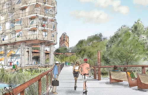
The Valley forms a unique opportunity to enhance and reinvent the landscape adjoining the River Medlock. It can deliver an ecological and recreational link between the City Centre and Sport City and the Etihad Campus. The floodplain requires careful regard for any development in this area.
Click on the map markers to view key features and to see the artist's sketches for this area.
Two clusters of tall buildings would balance with upgrades to the river corridor. These would improve
biodiversity, recreation, and play.
The culmination of this area will be at Confluence Park. The enhanced park setting would form the basis
for a single landmark tower of up to thirty-five storeys. This would have a destination play and
recreation space at its base.
Map Key
|
|
The Valley area boundary |
| Railway tracks |
| Metrolink tracks | |
| Metrolink stations |
| Proposed layout including buildings to be retained |
| More information |
| Artist's sketches |
Emerging Illustrative Framework
The indicative illustrative framework shown here presents one way Holt Town could look. This follows the design principles that the draft NDF sets out.
Scroll to the next section to give us your views.
Map Key
|
|
Holt Town NDF Boundary |
| Railway tracks |
| Metrolink tracks | |
| Metrolink stations |
| Proposed layout including buildings to be retained |
Give us your thoughts
This consultation for the Draft Neighbourhood Development Framework for Holt Town has now ended. Thank you to everyone who took part and provided feedback.
Thank you for taking the time to read more about our plans for Holt Town. We would love to hear from you.
Click on the button below to give us your views.
question_answer Give your feedback here
This consultation will close on Sunday 29th September 2024.
Next steps...
The project team are hosting in-person events during the formal consultation period.
These events are free to attend and there is no need to book a place in advance. To find out more
about these events and where they will be held,
If you can't attend an in-person event, but would still like to take part, please reach out to us and we can arrange an alternative. You can email us at engage@deetu.com.
Read the draft NDF in full
You may wish to learn even more detail about the draft NDF, having read through this website. If you would like to read the document in full, you can do so by clicking here. Please note, this link opens a new browser tab.
Holt Town, Wood Town
brought to you by:


An
Engaged Space community engagement presented by Deetu, on behalf of Manchester City Council (MCC)
Powered by
Deetu.
Got a story to tell?
Get in touch.

touch_app Back to the start